The Norwegian Satellite Earth Observation Database for Marine and Polar Research (NORMAP) is a 6 year project funded by the Norwegian Research Council (NRC) under the Infrastructure programme.
The overall goal of NORMAP is:
to create and maintain a data repository, including metadata of the high latitude and Arctic regions based on Earth Observation data from polar orbiting satellites to facilitate and stimulate high quality and original multidisciplinary Earth System research, application and education in marine, polar and climate sciences
Within the first two years the goals are to:
- design and establish the technical framework for the data repository and implement this;
- make available a set of selected quality controlled multidisciplinary scientific data products that will support air-sea-ice process studies, near real time applications for monitoring of environment and security and long time series for climate change purposes
- ensure interoperability with existing national and international data repositories
In the longer run (2-6 years) the goals are to:
- advance the effective use of satellite EO data by the scientific community so less time are spent searching and qualifying data giving more time to scientific studies and analyses
- maintain optimal quality control through regular reprocessing of the satellite data based on updated algorithms and data
- provide input to reliable initial and boundary conditions for climate change predictions
- stimulate use of satellite based EO data in higher education
- stimulate the use of satellite based EO data for assimilation in numerical models
- stimulate synergetic use of satellite EO data for advanced process studies and modelling on air-sea-ice interaction
- provide Earth Observation data for marine and climate research in the Svalbard Integrated Observing System (SIOS), a proposed ESFRI infrastructure for Arctic research (SIOS)
- transition to implementation and operation of a sustainable Norwegian Centre for Satellite Earth Observation.
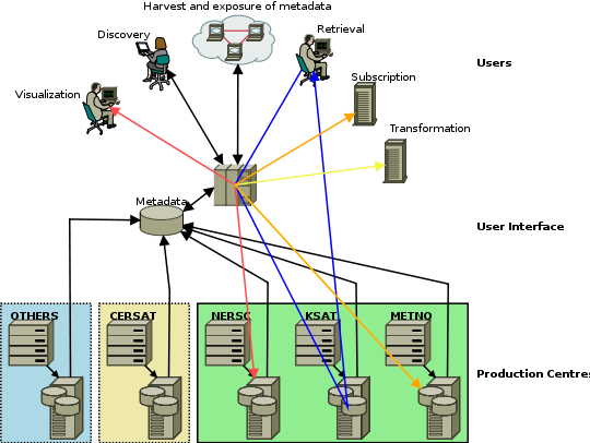
The physical outline of NORMAP with intended services is illustrated below.
Participants
Contact
Project coordinator: Johnny A. Johannessen (johnny.johannessen@nersc.no )
Nansen Environmental and Remote Sensing Center,
Thormohlensgt 47 5006 Bergen Phone: +47 55 20 58 00 Fax: +47 55 20 58 01 http://www.nersc.no
Data policy
The data may be used and redistributed for free but is not intended for legal use, since it may contain inaccuracies. The data Contributor does not make any warranty, express or implied, including warranties of merchantability and fitness for a particular purpose, or assumes any legal liability for the accuracy, completeness, or usefulness, of this information.